

In late winter, as in the previous 2 years, I began thinking about revisiting Yosemite Valley during the spring. Spring is the ideal time to visit Yosemite Valley; the water is running at its highest and the crowds are still relatively light. Unfortunately, 2018 saw an absolutely dry February, so snow levels were low and prospects for water appeared dim. However, the storms resumed travelling through Northern California in March, bringing estimates of a sub-normal but not absolutely dry year. So, in March, I beagan checking for openings in the reservation schedule for Yosemite Lodge during the 2nd week of April; a period when I had almost no obligations keeping me at home.
Late in the month, I managed to secure reservations at the Lodge for 2 mid-week days. I then made arrangements to stay in Goveland, about an hour out of the park’s northwest entrance the previous night. the weekend, a warm storm passed through. So, in addition to the rain falling, it also caused premature snowmelt. In fact, Yosemite Valley was evacuated over that weekend and the Merced River flooded at 5 feet over flood stage. However, by Sunday afternoon, the Valley was reopened to visitation. So on Tuesday it was off to Yosemite.
The photo albums for the trip are here. If you just want to browse all pictures for the trip, go here.
To the Valley
So, on Tuesday, I headed to Groveland, a small town that serves as the gateway to Yosemite on Hiway 120. Friendly Grizzlies at the local carwash greeted me.

Wednesday morning, I continued to the road summit at Crand Flat and then a gradually descended on Big Oak Flat Road to the west end of the Valley. Along the way, there were glimpses of Half Dome and of the Merced River Canyon. Before the final descent, the road bridged the upper reaches of Tamarack and Cascade Falls. Photos here.

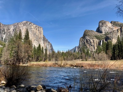
Once reaching the valley, the first stops are along the south wall of the valley: Bridalveil Falls and Tunnel View. From these stops, there are views of the falls, other west valley falls, and the massive rock structures of El Capitan and the Cathedral complex. Photos here

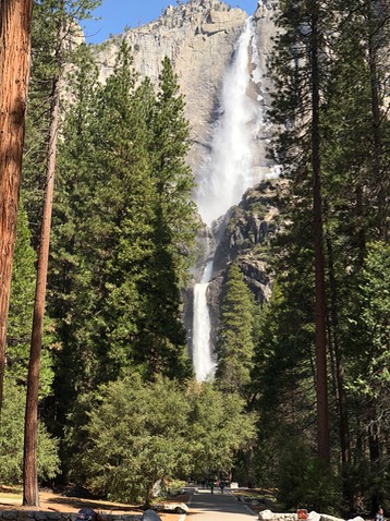
Finally, I reached Yosemite Lodge and took an afternoon stroll to Yosemite Falls and Yosemite Village before checking in. Dinner that night was in the Lodge restaurant with a view of the falls. Pictures here.

For all pictures related to this page, go here.
Full Day in the Valley

After breakfast, I took the Valley shuttle to Happy Valley and hiked toward Vernal Falls on the Mist Trail. Being early, the trail was uncrowded. It had been cold the night before and bridge over the Merced River below the falls was slippery with black ice. After stabilizing myself and taking a few pictures, I ontiued up the trail toward the falls. About 1/3 mile beyond the bridge, a view of the falls emerged from beyond a cliff. I took a few photos and then retraced my path to the bottom. I shuttled to the Camp Curry (now Half Dome Village) area where I spied a coyote and shot some photos of Half Dome. Pictures here.

I then shuttled to the main village for lunch. Afterwards, I walked up the road to the Majestic (Ahwahnee) Hotel, shooting pictures of the enveloping scenery. After hanging out in the meadows and along the old road leading to Mirror Lake, I returned to the Lodge. That evening, I returned to the Hotel for dinner in the magnificent dining room. Pictures here.
For all pictures releated to this page, go here.
Falls, Meadows, and Views
On the last day of the trip, I packed and checked out and then hiked the loop to Lower Yosemite Falls. It had been cold overnight, so there was ice from the mist sprayed on the walls of the upper falls. In shaded areas alond the creek below the falls, there were substantial patches of snow. Pictures here.
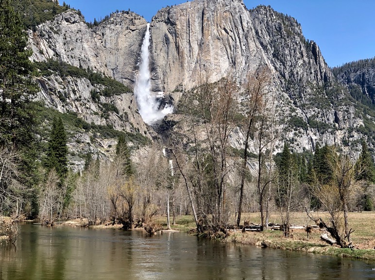
Once I returned to the road, I crossed over to Cook’s Meadow. A large pond was present in the meadow, praboaly created by the flood the previous weekend.I made my way to Sentinel Bridge to recapture the famous picture of Half Dome over the Merced River. I continued along the path between Sentinel Meadow and Southside Road to Swinging Bridge and more pictures of valley walls and falls over the swollen river. I then returned to my car at the Lodge through Leidig Meadow. Pictures here.
As I drove out of the Valley, I made one last stop at an almost forgotten viewpoint, Valley View. Before congestion in the valley became severe, people were able to drive into the valley on Northside Road and access this this spot along the Merced River, just east of the Pohono Bridge, the westernmost of the Valley bridges. Now, because it’s positioned on the exit road, it is where one can get a final view. Picture here.

For all pictures releated to this page, click here.